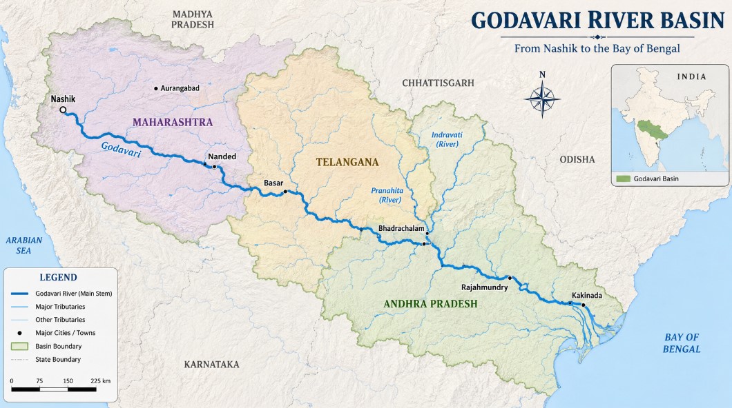
The Godavari River, often revered as the Dakshin Ganga (Ganga of the South) or Vridha Ganga (Old Ganga), is not just a water body; it is the geographical and cultural spine of Peninsular India. Spanning nearly 1,465 km, it stands as the second-longest river in India after the Ganga. For any serious aspirant or geography enthusiast, understanding the Godavari is crucial because its basin covers nearly 10% of India's total geographical area.
In this detailed guide, we will dissect the Godavari River system—from its mystic origin in the Western Ghats to its sprawling delta in the Bay of Bengal—using a high-quality educational lens.
1. The Origin and Source: Trimbakeshwar
The journey of the Godavari begins at Trimbak (Trimbakeshwar) in the Nashik district of Maharashtra. Situated in the Western Ghats, the river emerges at an elevation of about 1,067 meters.
Why is it called "Vridha Ganga"?
Geologically, the Peninsular rivers are much older than the Himalayan rivers like the Ganga or Brahmaputra. The Godavari is referred to as "Vridha" (Old) because it has reached a mature stage of river development, characterized by broad, shallow valleys and a graded profile.
2. The Course of the River: From Ghats to the Coast
The Godavari follows a southeasterly course across the Deccan Plateau. Its journey is a masterclass in Indian geography:
- Upper Reach: It flows through the rain-shadow region of the Western Ghats in Maharashtra.
- Middle Reach: It enters Telangana and forms the border between Telangana and Maharashtra/Chhattisgarh.
- Lower Reach: It traverses through the Eastern Ghats via a narrow gorge at Papi Hills before entering the plains of Andhra Pradesh.
- The Delta: Near Rajahmundry, the river splits into two main distributaries—the Gautami Godavari (East) and the Vashishta Godavari (West)—creating a massive lobate delta before draining into the Bay of Bengal.
Basin Statistics (State-wise)
The Godavari basin extends over an area of approximately 3.12 lakh sq. km.
| State | Percentage of Basin Area |
|---|---|
| Maharashtra | ~48.6% (The largest share) |
| Telangana & Andhra Pradesh | ~23.4% |
| Chhattisgarh | ~10% |
| Madhya Pradesh | ~10% |
| Odisha, Karnataka & Puducherry | Remaining balance |
3. The Tributary Network: The Lifeblood of the Basin
The Godavari is fed by an intricate network of tributaries. These are classified into Left Bank and Right Bank tributaries.
A. Left Bank Tributaries (The Heavy Hitters)
These tributaries contribute the bulk of the water volume to the Godavari.
- Dharna: The first major tributary joining the river in Maharashtra.
- The Pranahita System: This is the largest tributary of the Godavari, contributing nearly 34% of its total drainage. It is formed by the confluence of three rivers:
- Wardha: Originates in the Satpura Range.
- Painganga: Originates in the Ajanta ranges.
- Wainganga: Originates in the Mahadeo Hills.
- Indravati: Often called the "Lifeline of Bastar," it flows through Chhattisgarh and is known for the famous Chitrakote Falls (The Niagara of India).
- Sabari: The last major left-bank tributary, joining near Kunavaram.
B. Right Bank Tributaries
While fewer in number, they are vital for irrigation in the arid regions of the Deccan.
- Pravara: Originates in the Western Ghats; its catchment is heavily utilized for sugar cultivation.
- Manjra: The most significant right-bank tributary. It flows through the Balaghat range and is the primary water source for the Nizam Sagar Dam.
- Maner: Joins the Godavari in Telangana.
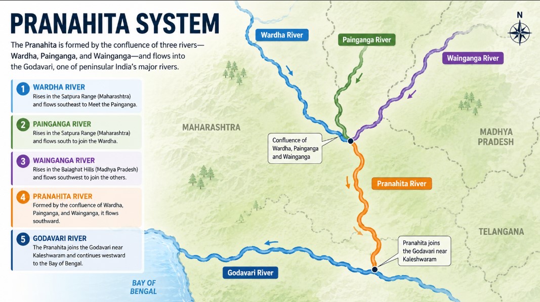
*Image visuals contain some mistakes because the image was AI-generated.
4. Major Multipurpose Projects and Dams
The Godavari is the backbone of the agrarian economy in Central and Southern India. Several mega-projects harness its potential:
- Jaikwadi Project (Paithan): Located in Maharashtra, it is one of the largest earthen dams in India, primarily used for irrigation in the drought-prone Marathwada region.
- Sri Ram Sagar Project (Pochampad): A lifeline for Northern Telangana, serving districts like Nizamabad and Karimnagar.
- Polavaram Project: A massive under-construction multipurpose national project in Andhra Pradesh designed to divert water to the Krishna basin and provide massive irrigation/power benefits.
- Kaleshwaram Lift Irrigation Project (KLIP): One of the world's largest multi-stage lift irrigation projects, designed to transform the landscape of Telangana.
5. Ecology and Environmental Challenges
The Godavari Delta and Mangroves
The Godavari delta is home to the Coringa Mangroves, the second-largest mangrove formation in India after the Sundarbans. This region is a biodiversity hotspot, providing habitat for the endangered Fishing Cat and various migratory birds.
Challenges: A Double-Edged Sword
- Floods: During the monsoon, the lower reaches (especially in Andhra Pradesh) face devastating floods due to the high volume of water brought by the Indravati and Pranahita.
- Droughts: Paradoxically, the upper basin in Maharashtra (Marathwada) suffers from severe water scarcity and "rain-shadow" effects.
- Pollution: Industrial discharge in Nashik and Hyderabad (via Musi/Manjra) has significantly impacted water quality.
6. Current Affairs: Interlinking of Rivers
The Godavari-Cauvery Link is a major highlight in recent national infrastructure planning. The project aims to divert surplus water from the Godavari (specifically from the Inchampalli/Janampet point) to the Krishna and then to the Cauvery. This "Grid of Rivers" is expected to solve the water crisis in the southern states of Tamil Nadu and Karnataka.
7. Conclusion
The Godavari River System is a testament to India's geographical diversity. From the spiritual ghats of Nashik to the industrial hubs of Telangana and the fertile rice bowls of Andhra Pradesh, it sustains millions. For students and policymakers alike, the sustainable management of the "Dakshin Ganga" remains paramount to ensuring the food and water security of India.