Introduction: Why Mountain Passes Matter in Maharashtra
Maharashtra, one of India's most geographically diverse states, rests on the lush and rugged lap of the Sahyadri mountain range — the backbone of the Western Ghats. This range, running parallel to the western coastline, creates a natural divide between the coastal Konkan region and the interior Deccan Plateau.
But nature always finds a way — and in Maharashtra's case, these ways are called Ghats or Mountain Passes.
A mountain pass (ghat) is a navigable route through a mountain range or over a ridge. In Maharashtra, these passes have served as arteries of civilisation — facilitating trade, military campaigns, pilgrimages, and today, modern transport and tourism. From the reign of the Satavahana dynasty to the campaigns of Chhatrapati Shivaji Maharaj, and from bullock carts to national highways, Maharashtra's ghats have witnessed it all.
For students preparing for MPSC Rajyaseva, MPSC Group B/C, Maharashtra Police, Talathi, and other State-level exams, mountain passes form a critical topic under Geography of Maharashtra (GS Paper I). Questions range from identifying which pass connects which cities, to the north-to-south chronological order of ghats, to historical significance — making this a high-yield topic.
What is a Ghat / Mountain Pass?
The word "Ghat" in Marathi literally means a "stepped descent" or a "pass through hills." Geographically, a ghat is:
- A low point or gap in a mountain ridge that allows passage from one side to the other
- Often formed by river erosion, tectonic activity, or glacial action over millions of years
- In Maharashtra's context, ghats connect the Konkan (coastal) strip with the Desh (plateau) region
These passes dramatically reduce travel distance and time — without them, crossing the Sahyadri would require going around hundreds of kilometres of rugged terrain.
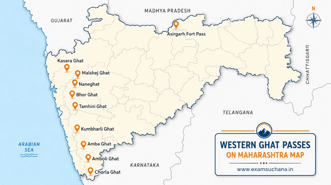
Complete List of Mountain Passes in Maharashtra
The following table lists all major mountain passes in Maharashtra along with the places they connect — a must-memorise chart for any competitive exam aspirant:
| Mountain Pass (Ghat) | Places Connected |
|---|---|
| Shirghat / Shirsat | Nashik ↔ Jawhar |
| Fonda Ghat | Sawantwadi ↔ Kolhapur ↔ Panaji (Goa) |
| Chandanapuri Ghat | Pune ↔ Nashik |
| Rupatya Ghat | Pune ↔ Mahad |
| Sarsa | Sironcha ↔ Chandrapur |
| Kashedi Ghat | Mahad ↔ Khed ↔ Dapoli |
| Katraj Ghat | Pune ↔ Satara |
| Pasarni Ghat | Panchgani (Satara) ↔ Wai |
| Bhor Ghat | Mumbai ↔ Pune (via Khopoli) |
| Warandha Ghat | Pune ↔ Mahad |
| Malshej Ghat | Mumbai ↔ Nashik / Thane ↔ Ahmednagar |
| Tamhini Ghat | Pune ↔ Mangao |
| Radtondi Ghat | Mahad ↔ Mahabaleshwar |
| Thal Ghat (Kasara Ghat) | Mumbai ↔ Nashik |
| Hatlot Ghat | Satara ↔ Ratnagiri |
| Kelzar Ghat | Satara ↔ Ratnagiri |
| Fitzgerald Ghat | Mahabaleshwar ↔ Alibag |
| Karul Ghat | Kolhapur ↔ Rajapur / Vijaydurg |
| Kumbharli Ghat | Satara ↔ Ratnagiri (Chiplun ↔ Karad) |
| Amba Ghat | Kolhapur ↔ Ratnagiri |
| Anuskura Ghat | Kolhapur ↔ Rajapur |
| Autram Ghat (Kannada Ghat) | Chhatrapati Sambhaji Nagar ↔ Dule |
| Dive Ghat | Pune ↔ Baramati |
| Ambenali Ghat | Mahabaleshwar ↔ Poladpur (Raigad ↔ Satara) |
| Ram Ghat | Kolhapur ↔ Sawantwadi |
| Gagandbawada Ghat | Kolhapur ↔ Kharepatan |
| Utter Tive Ghat | Satara ↔ Rari |
| Nane Ghat (Naneghat) | Mumbai ↔ Ahmednagar (Kalyan ↔ Junnar) |
| Laling Ghat | Nashik ↔ Dhule |
| Hanumante Ghat | Kolhapur ↔ Kudal / Kanakwali |
| Kusur Ghat | Pune ↔ Panvel |
| Amboli Ghat | Sawantwadi ↔ Belgaum (Karnataka) |
| Bhimashankar Ghat | Panvel ↔ Narayangaon / Pune ↔ Mahad |
Important Mountain Passes in Maharashtra — Detailed Notes
Let's now dive deep into the most frequently asked and most significant ghats from an exam and knowledge perspective:
1. Thal Ghat (Kasara Ghat / Thul Ghat)
Location: Kasara, Thane District, Maharashtra
Connects: Mumbai ↔ Nashik
One of the most strategically vital passes in Maharashtra, Thal Ghat sits in the Sahyadri range of the Western Ghats. It is one of the four major entry/exit routes into Mumbai — via road and rail.
Key Facts:
- The railway line passing through Thal Ghat is considered the steepest railway line in India
- Also known as Kasara Ghat or Thul Ghat
- Lies on the Mumbai–Nashik highway corridor
- Of immense importance for freight movement and passenger traffic from North Maharashtra to Mumbai
Exam Tip: Remember — "Thal Ghat = Steepest railway in India"
2. Bhor Ghat
Location: Near Khandala, Sahyadri Range
Connects: Mumbai ↔ Pune (via Khopoli–Khandala)
Bhor Ghat is arguably Maharashtra's most historically significant mountain pass. It served as an ancient trade route developed by the Satavahana dynasty to link the Konkan ports of Choul, Revdanda, and Panvel with the Deccan Plateau.
Key Facts:
- The railway route passes between Palasdari and Khandala; road route goes via Khopoli to Khandala
- Falls under the proposed Golden Quadrilateral Freight Corridor
- Located at the crest of the Western Ghats
- The easiest passage from Mumbai to Khopoli and onward to Pune
- Famous for the Khandala hill station located nearby
Exam Tip: "Bhor Ghat = Mumbai to Pune, Satavahana trade route, Golden Quadrilateral link"
3. Malshej Ghat
Location: Sahyadri Range, between Kalyan and Ahmednagar
Connects: Mumbai / Thane ↔ Nashik / Ahmednagar
Malshej Ghat is a jewel in Maharashtra's crown of mountain passes. Known for its extraordinary biodiversity and bird watching, it receives heavy rainfall and transforms into a misty paradise during the monsoon.
Key Facts:
- Famous for its diverse birdlife: quails, rails, crakes, flamingos, and cuckoos
- Abundant waterfalls during monsoon season
- Popular weekend destination from Mumbai and Pune
- Located in the Western Ghats / Sahyadri Range
- Connects Thane district to Ahmednagar
Exam Tip: "Malshej Ghat = Famous for flamingos and migratory birds"
4. Nane Ghat (Naneghat / Nana Ghat)
Location: Junnar region, Pune district
Connects: Kalyan (Mumbai region) ↔ Junnar (Ahmednagar)
Naneghat has an extraordinary historical legacy. The name comes from "नाणे" (Nane) meaning coin in Marathi, because this pass served as a toll collection point — essentially a tollbooth of ancient India — during the Satavahana era.
Key Facts:
- Used as an ancient trade route with tax/toll collection points
- Contains caves with Hindu Sanskrit inscriptions in Brahmi script
- Famous for a reverse waterfall phenomenon
- The Shivneri Fort (birthplace of Chhatrapati Shivaji Maharaj) in Junnar is easily accessible from this pass
- Significant during Satavahana rule for commercial activity
Exam Tip: "Naneghat = Coin pass, Satavahana toll, reverse waterfall, near Shivneri fort"
5. Amboli Ghat
Location: Sindhudurg District, South Maharashtra
Connects: Sawantwadi (Maharashtra) ↔ Belgaum (Karnataka)
Amboli Ghat marks the southern boundary of the Western Ghats in Maharashtra and is famed for its lush forests, waterfalls, and rich biodiversity.
Key Facts:
- Located in Sindhudurg district
- Home to numerous waterfalls and dense hilly forests with rich wildlife
- Famous Hiranyakeshi Temple is located at this ghat
- Connects Maharashtra to Karnataka (Belgaum)
- Part of the Sahyadri Range of Western Ghats
6. Amba Ghat
Location: Near Shahuwadi, Kolhapur District
Connects: Kolhapur ↔ Ratnagiri
Amba Ghat is a scenic mountain pass connecting the interior Deccan city of Kolhapur with the coastal Ratnagiri district.
Key Facts:
- Located in the Sahyadri Mountains of the Western Ghats
- Famous for paragliding and adventure tourism
- Scenic mountains with a pleasant climate year-round
- Popular among trekkers and nature lovers
7. Kumbharli Ghat
Location: Western Ghats, Satara–Ratnagiri corridor
Connects: Satara ↔ Ratnagiri (Karad ↔ Chiplun)
Kumbharli Ghat is the key connector between the Konkan and Desh (Deccan) regions in the Satara–Ratnagiri sector.
Key Facts:
- Connects Ratnagiri and Satara districts
- Multiple waterfalls during monsoon season
- Situated in Maharashtra's Western Ghats
- Important for the agriculture and transport sectors of both districts
8. Tamhini Ghat
Location: Mulshi Taluka and Tamhini, Pune District
Connects: Pune ↔ Mangao (Konkan)
Tamhini Ghat is a favourite monsoon destination for Pune residents. It lies in the heart of the Sahyadri and is one of the greenest ghats in Maharashtra.
Key Facts:
- Located in Sahyadri Range of Western Ghats
- Famous for scenic waterfalls and heavy greenery during monsoons
- Connects Mulshi and Tamhini talukas of Pune district
- Popular for trekking and photography
9. Anuskura Ghat
Location: Kolhapur region
Connects: Kolhapur ↔ Rajapur
This pass holds a unique historical distinction — it was used by Chhatrapati Shivaji Maharaj to enter Tal Konkan and Rajapur during his military campaigns.
10. Khambatki Ghat
Location: Intersection of Pune and Satara districts
Connects: Pune ↔ Bengaluru (NH route)
Key Facts:
- Located in the Sahyadri mountain ranges
- Used by travellers going to Mahabaleshwar and Panchgani via Pune
- Connects important tourist destinations including Sajjangad and Kaas Plateau (UNESCO World Heritage Site)
- Dual-use ghat: transport corridor as well as tourist gateway
11. Chorla Ghat
Location: Tri-junction of Maharashtra, Karnataka, and Goa
Connects: Maharashtra ↔ Goa ↔ Karnataka
Key Facts:
- Located at the meeting point of three state borders
- Famous for the rare species of wolf snake (Lycodon striatus)
- Popular ecotourism destination due to Sahyadri's biodiversity
- A nature lover's paradise at the southern tip of Maharashtra
12. Ambenali Ghat
Location: Satara–Raigad border
Connects: Mahabaleshwar ↔ Poladpur (Raigad ↔ Satara)
Key Facts:
- Connects the famous hill station of Mahabaleshwar (Satara) with Poladpur in Raigad district
- Part of the route used by tourists visiting Mahabaleshwar from coastal Maharashtra
North-to-South Directional Order of Mountain Passes — Most Important for MPSC!
MPSC frequently tests candidates on the sequential order of ghats from north to south or south to north. Memorise this order carefully:
NORTH ↓ SOUTH
- Thal Ghat (Kasara Ghat)
- Malshej Ghat
- Bhor Ghat
- Varandha Ghat
- Radtondi (Rantundi) Ghat
- Kumbharli Ghat
- Amba Ghat
- Fonda Ghat
- Amboli Ghat
## Historical Significance of Maharashtra's Mountain PassesMemory Trick: "True Men Build Very Robust Kingdoms And Fight Against All"
(Thal, Malshej, Bhor, Varandha, Radtondi, Kumbharli, Amba, Fonda, Amboli)
Maharashtra's ghats are not merely geographical features — they are living chapters of history:
| Historical Connection | Ghat Involved |
|---|---|
| Satavahana dynasty trade routes to Konkan ports | Bhor Ghat, Naneghat |
| Chhatrapati Shivaji Maharaj's military entry into Tal Konkan | Anuskura Ghat |
| Ancient toll collection point (coin pass) | Nane Ghat (Naneghat) |
| Trade route to Goa and South India | Fonda Ghat, Amboli Ghat |
Economic and Strategic Importance
Mountain passes in Maharashtra serve far beyond historical or tourism roles:
- Transport Efficiency — They drastically reduce travel time and distance between Konkan and Deccan regions
- Trade and Commerce — Facilitated ancient and modern trade between the coast and the hinterland
- Tourism Revenue — Ghats like Malshej, Tamhini, Amboli, and Amba generate significant tourism income
- Agricultural Connectivity — Enable transport of agricultural produce from Konkan (rice, fruits) to Deccan markets
- Strategic Military Use — Historically used by Maratha forces for surprise attacks and territorial control
- National Highways — Modern highways like the Mumbai–Pune Expressway (Bhor Ghat sector) are built along these natural passages
Quick Revision — Key Facts Summary Table
| Ghat | Special Feature / Fact |
|---|---|
| Thal Ghat | Steepest railway line in India |
| Bhor Ghat | Mumbai–Pune; Satavahana trade route; Golden Quadrilateral |
| Naneghat | Coin/toll pass; Satavahana era; Reverse waterfall; Near Shivneri fort |
| Malshej Ghat | Famous for flamingos and migratory birds |
| Amboli Ghat | Hiranyakeshi Temple; Connects to Karnataka |
| Amba Ghat | Famous for paragliding |
| Chorla Ghat | Rare wolf snake (Lycodon striatus); Tri-state junction |
| Anuskura Ghat | Used by Chhatrapati Shivaji Maharaj |
| Khambatki Ghat | Gateway to Mahabaleshwar, Panchgani, Kaas Plateau |
| Fonda Ghat | Connects Sawantwadi–Kolhapur–Panaji (Goa) |
Practice MCQs — Mountain Passes in Maharashtra
Maharashtra's mountain passes (ghats) are far more than geographical corridors — they are the veins through which the state's trade, culture, history, and ecology flow. From the steepest railway at Thal Ghat to the ancient coin-toll of Naneghat, from the Satavahana trade routes of Bhor Ghat to the Shivaji-era military corridor of Anuskura Ghat, these passes have shaped Maharashtra's destiny across millennia.
For MPSC aspirants, this topic demands both rote learning (connecting cities, directional order) and conceptual understanding (historical, ecological, economic significance). Master this chapter, and you can confidently answer 2–4 questions in the Preliminary Exam on this topic alone.
"Know your terrain — it's not just geography, it's Maharashtra's identity."