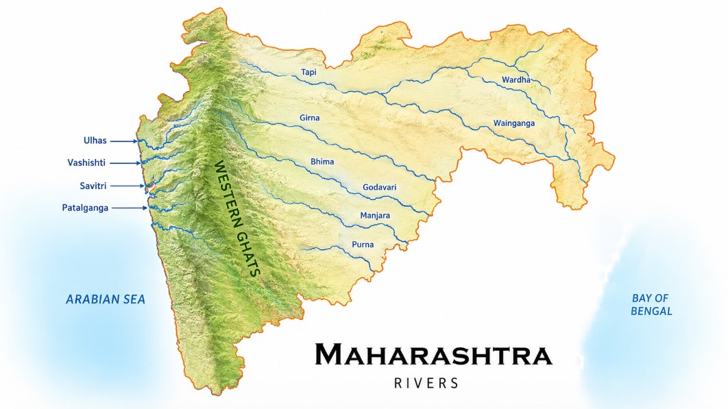
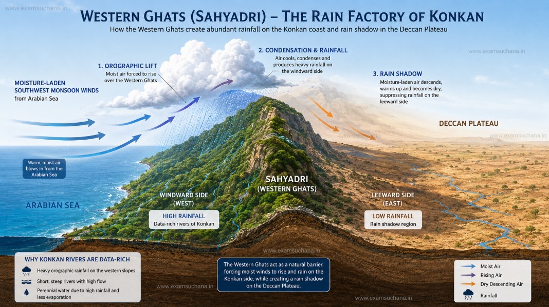
Maharashtra sits on the Deccan Plateau, a vast elevated landmass. At its western edge runs the majestic Sahyadri Mountain Range (Western Ghats), which acts as the primary watershed (water divide) of the entire peninsula.
Here is the key geographic logic you must internalize:
The Western Ghats (Sahyadri) are so close to the western coast that rivers originating on the western slopes have a short but steep path to the Arabian Sea, while rivers on the eastern slopes travel a much longer distance to reach the Bay of Bengal.
This is why:
- West Flowing Rivers → Originate in Sahyadri → Flow west → Drain into the Arabian Sea
- East Flowing Rivers → Originate in Sahyadri → Flow east → Drain into the Bay of Bengal (via the Godavari, Krishna, Bhima, etc.)
Characteristics of West Flowing Rivers of Maharashtra
Before we name the rivers, let's understand what makes these rivers unique. This is the kind of conceptual clarity that separates toppers from the rest.
| Feature | West Flowing Rivers | East Flowing Rivers |
|---|---|---|
| Origin | Western slopes of Sahyadri | Eastern slopes of Sahyadri / Deccan |
| Length | Short (50–150 km typically) | Long (500–1400 km) |
| Gradient | Very steep | Gentle, gradual |
| Speed | Fast-flowing, energetic | Slow, meandering |
| Drainage into | Arabian Sea | Bay of Bengal |
| Valley type | Narrow, gorge-like | Broad, open valleys |
| Economic significance | Hydropower, fish landing ports | Irrigation, agriculture |
Key Insight for Exam: West flowing rivers are shorter but faster. Their steep gradient makes them ideal for hydropower generation. This is why many of Maharashtra's major dams for power generation lie on these rivers.
List of Major West Flowing Rivers of Maharashtra
Now let us systematically cover each important river. Remember — in geography, the direction of flow, the origin point, and the mouth (where it meets the sea) are the three facts you must lock in for each river.
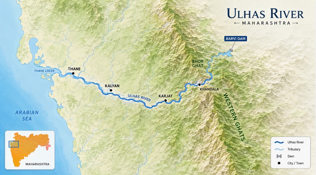
1. Ulhas River
- Origin: Sahyadri hills near Khandala (Pune district), specifically the Bhor Ghat area
- Length: Approximately 122 km
- Flows through: Pune → Raigad → Thane
- Meets: Arabian Sea (Creek near Mumbai, merges into Thane Creek and then Vasai Creek)
- Tributaries: Bhatsai, Kalu
- Key Dams / Reservoirs: Barvi Dam on the Kalu tributary (supplies water to Mumbai's suburbs)
Why it matters: The Ulhas River basin is critical for Mumbai Metropolitan Region's water supply. Its estuary is an ecologically sensitive zone — home to mangroves, migratory birds, and diverse marine life. The Ulhas River Valley was historically the gateway between the Deccan plateau and the Konkan coast.
2. Patalganga River
- Origin: Sahyadri range near Khopoli (Raigad district)
- Length: Approximately 50 km
- Flows through: Raigad district — passes through Khopoli and Panvel region
- Meets: Thane Creek (Arabian Sea)
- Special Significance: The Patalganga Industrial Area near Khopoli is one of Maharashtra's major industrial corridors. The river's basin hosts chemical and pharmaceutical industries.
Memory Hook: "Patala" means underground/netherworld — this river has a portion that flows through rocky, gorge-like terrain, hence the name.
3. Kundalika River (Roha River)
- Origin: Sahyadri near Roha (Raigad district)
- Length: Approximately 56 km
- Flows through: Raigad district
- Meets: Rajpuri Creek (Arabian Sea), near Murud
- Significance: The river passes close to the historic Murud-Janjira Fort, the only unconquered sea fort on India's western coast. The Kundalika basin has some of Maharashtra's lush cashew and kokum plantations.
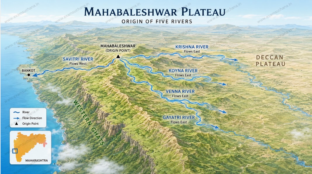
4. Savitri River
- Origin: Mahabaleshwar (Satara district) — one of the most celebrated river origins in Maharashtra
- Length: Approximately 98 km
- Flows through: Satara → Raigad
- Meets: Arabian Sea near Bankot (Harihareshwar area)
- Dams: Dhom Dam (shared watershed near Mahabaleshwar)
Key Fact for Exam: Mahabaleshwar is unique — it is the origin of five rivers: Krishna (east), Koyna (east), Venna (east), Gayatri (east), and Savitri (west). This makes it one of India's most important hydrological source points.
5. Vashishti River (Vasishti)
- Origin: Near Medha in Satara district, Sahyadri range
- Length: Approximately 64 km
- Flows through: Satara → Ratnagiri
- Meets: Arabian Sea at Dabhol (Ratnagiri district)
- Key Dams: Koyna Dam releases water that joins the Vashishti system at lower stretches via canals
- Significance: The Dabhol Power Plant (now Ratnagiri Gas & Power Pvt Ltd) is located near the mouth of this river — one of India's largest LNG-based power plants.
Exam Alert: The Vashishti River's estuary at Dabhol has a natural creek that provided the ideal location for a large industrial port and power plant.
6. Shastri River
- Origin: Sahyadri range in Ratnagiri district
- Length: Approximately 45 km
- Flows through: Ratnagiri district
- Meets: Arabian Sea near Jaigad
- Significance: The river forms a beautiful backwater estuary near Jaigad, where the Jaigad Fort stands. The estuary is known for oyster and fish cultivation.
7. Jagbudi River (Muchkundi)
- Origin: Sahyadri in southern Ratnagiri district
- Meets: Arabian Sea near Ratnagiri town
- Significance: Ratnagiri town and port are located on this river's estuary. Historically, this was one of the key trading ports of the Konkan.
8. Muchkundi / Ratnagiri River
- Flows through Ratnagiri district and merges into Arabian Sea.
9. Kajvi River
- Origin: Sahyadri in Sindhudurg district
- Flows through: Sindhudurg
- Meets: Arabian Sea
10. Terekhol River (Tiracol)
- Origin: Sahyadri range in Sindhudurg district
- Length: Approximately 60 km
- Flows through: Southern Sindhudurg → forms the Maharashtra-Goa border
- Meets: Arabian Sea at Terekhol (border of Maharashtra and Goa)
- Key Fact: This river forms the natural boundary between Maharashtra's Sindhudurg district and Goa. The Terekhol Fort is located at its mouth.
11. Gad River (Gadnadi)
- Origin: Sahyadri in Sindhudurg
- Meets: Arabian Sea near Vijaydurg
- Significance: The Vijaydurg Fort — the "Gibraltar of the East" and Maratha naval stronghold — sits at this river's estuary. Kanhoji Angre, the great Maratha admiral, operated from here.
Konkan — The Playground of West Flowing Rivers
All the west-flowing rivers of Maharashtra drain into the Konkan coastal strip — a narrow but fertile coastal plain between the Sahyadri and the Arabian Sea. Understanding this geography is crucial.
- Konkan covers parts of Raigad, Ratnagiri, and Sindhudurg districts (plus Mumbai and Thane)
- The region receives heavy monsoon rainfall (2,000–3,500 mm annually) because the Sahyadri acts as an orographic barrier, forcing moisture-laden Arabian Sea winds to rise and condense
- West-flowing rivers here are short, swift, and seasonal — most are perennial near the coast due to the high rainfall but diminish greatly in summer
Economic Importance of West Flowing Rivers
1. Hydropower Generation
The steep gradient of west-flowing rivers is harnessed at several key projects:
- Koyna Hydroelectric Project — Though Koyna River flows east, its water is diverted westward through tunnels to power stations on the western slopes. This is Maharashtra's largest power project (~1,960 MW).
- Bhira Project (Tata Power) — On the Patalganga system; one of India's oldest hydroelectric projects (1919).
- Khopoli Project (Tata Power) — Also on the Bhira-Patalganga basin.
2. Irrigation
Despite being short, west-flowing rivers support Konkan agriculture: rice paddies, coconut, areca nut, cashew, mango, jackfruit, and kokum.
3. Fisheries and Ports
River estuaries (creeks) form natural fishing harbors: Ratnagiri, Jaigad, Dabhol, Harnai are all estuary-based fish landing centers. Pomfret, mackerel, Bombay duck, prawns — all harvested in these waters.
4. Historical Significance
Maratha naval power was built on these estuaries. Forts at Vijaydurg (Gad River), Janjira (Kundalika), and Terekhol all command river mouths — a military strategy that allowed the Marathas to control sea trade.
Conceptual Summary Table — Quick Revision
| River | Origin | Drains into (Location) | District |
|---|---|---|---|
| Ulhas | Bhor Ghat / Khandala | Thane Creek / Arabian Sea | Thane, Raigad |
| Patalganga | Khopoli, Sahyadri | Thane Creek | Raigad |
| Kundalika | Roha, Sahyadri | Rajpuri Creek (Murud) | Raigad |
| Savitri | Mahabaleshwar | Arabian Sea (Bankot) | Raigad, Satara |
| Vashishti | Medha, Satara | Arabian Sea (Dabhol) | Satara, Ratnagiri |
| Shastri | Ratnagiri Sahyadri | Arabian Sea (Jaigad) | Ratnagiri |
| Gad | Sahyadri | Arabian Sea (Vijaydurg) | Sindhudurg |
| Terekhol | Sindhudurg Sahyadri | Arabian Sea (Goa border) | Sindhudurg |
Sample MCQ Practice Questions
(https://examsuchana.in/godavari-river-system-origin-tributaries-basin) and Krishna systems.]
Key Takeaways for Exam Preparation
- Sahyadri = Water Divide — Always start with this as your anchor concept.
- Short + Steep = West Flowing — The shorter, faster, gorge-cutting rivers of Konkan.
- 5 Rivers from Mahabaleshwar — Krishna, Koyna, Venna, Gayatri (east) + Savitri (west).
- Terekhol = Maharashtra-Goa Border River — A classic boundary question.
- Industrial Significance — Patalganga (chemical belt), Vashishti (Dabhol Power), Ulhas (Mumbai water supply).
- Military-Historical Angle — Gad River (Vijaydurg), Kundalika (Janjira), Terekhol (Terekhol Fort).
- Koyna diversion — Water flows east but is diverted west for power — a frequently tested concept.
References & Further Reading
- Maharashtra State Gazetteer — Geographical Overview
- MPSC Geography Notes — Maharashtra Rivers Module
- NCERT Physical Geography of India (Class 11)
- Survey of India — Maharashtra Drainage Maps
- National Water Development Agency (NWDA) — Konkan River Studies